Recent advancements in correction algorithms, particularly ACOLITE, are reshaping the precision with which we can monitor critical water quality parameters.
The Atmospheric Barrier in Ocean Color Analysis
Satellite sensors like those aboard Sentinel-3 capture radiation that has already traversed the atmosphere twice: once as solar radiation reaches Earth's surface, and again as it reflects back toward the satellite.
This atmospheric pathway introduces multiple distortions:
- Rayleigh scattering from air molecules
- Mie scattering from aerosols
- Absorption by water vapor and other gases
- Specular reflection (sun glint) at the air-water interface
In coastal and inland waters, the atmospheric contribution to the total signal received by satellite sensors is substantial, often accounting for the majority of the measured radiance.
The remaining fraction contains the actual water-leaving radiance that carries valuable information about water constituents, which is the data scientists need for water quality assessment.
The Evolution of Correction Methodologies
Traditional atmospheric correction methods developed for open-ocean applications have consistently underperformed in complex coastal environments. These methods typically rely on assumptions that break down in waters with unusual conditions, such as high sediment loads, dense phytoplankton blooms, shallow bottoms with benthos visibility, et cetera.
The limitations of these approaches have historically constrained the utility of satellite data for monitoring some of the most ecologically and economically important waters on the planet.
ACOLITE: A Pathway to Improved Atmospheric Correction
The ACOLITE (Atmospheric Correction for OLI 'lite') processor, developed by the Royal Belgian Institute of Natural Sciences, represents an advancement in addressing these challenges. The processor was initially designed for Landsat 8 OLI and later extended to Sentinel-2 MSI data, with ongoing development to support additional sensors.
Through extensive comparative analysis, our research team has identified ACOLITE as the superior option for operational water quality monitoring, particularly in complex coastal environments.
Technical Differentiators of the ACOLITE Approach
1. Dark Spectrum Fitting (DSF) Methodology
ACOLITE's DSF method works by:
- Creating a dark spectrum from the darkest pixels in an image
- Modeling atmospheric path reflectance across all available bands
- Applying this atmospheric model to derive water-leaving reflectance
This approach differs from conventional methods that often rely solely on near-infrared (NIR) or shortwave infrared (SWIR) bands for atmospheric correction.
2. Performance in Optically Complex Waters
Research has shown that ACOLITE performs more effectively in turbid coastal environments through:
- Utilization of the SWIR bands for atmospheric correction
- Reduction of adjacency effects from nearby land masses
- Handling of sun glint contamination in certain conditions
3. Comparative Analysis
Studies comparing ACOLITE with other processors have found:
- Improved retrieval of water reflectance in turbid waters compared to standard NIR-based algorithms
- Better handling of spatial variability in atmospheric conditions
- More consistent results across varying water types
4. Model-Agnostic Approach
ACOLITE primarily focuses on atmospheric correction rather than incorporating assumptions about inherent optical properties (IOPs) of the water body, which can introduce systematic bias in other processors. This is advantageous when working across diverse water bodies.
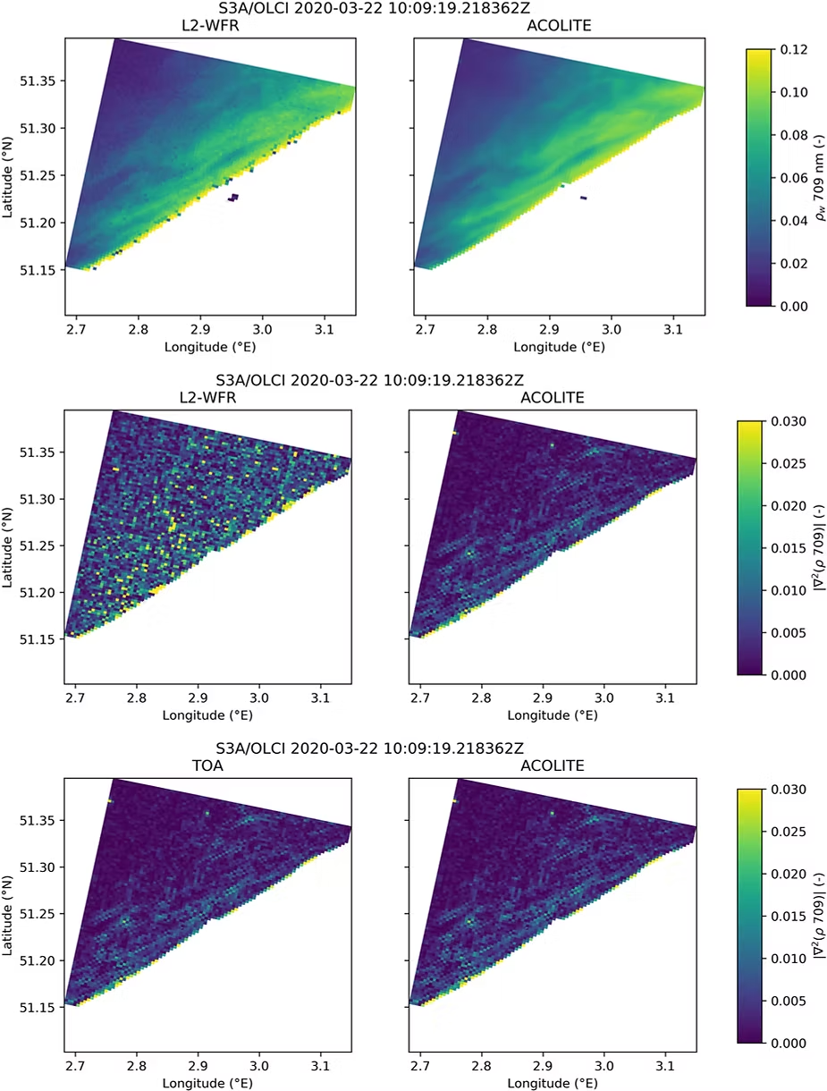
Comparison of two different methods for processing satellite imagery of water bodies: the standard approach (L2-WFR, shown on the left column) and the ACOLITE method (shown on the right column). ACOLITE method produces cleaner, more consistent measurements with less noise. Source: Atmospheric correction of Sentinel-3/OLCI data for mapping of suspended particulate matter and chlorophyll-a concentration in Belgian turbid coastal waters, by Quinten Vanhellemont and Kevin Ruddick (2021).
Practical Applications
The atmospheric correction provided by ACOLITE enables monitoring of water quality
parameters including:
Turbidity Measurement
Satellite-derived turbidity measurements allow researchers to:
- Track sediment plumes in coastal environments
- Monitor changes in water clarity over time
- Assess the impact of storm events on water quality
Chlorophyll-a Estimation
Satellite-based chlorophyll-a monitoring supports:
- Detection of algal blooms
- Assessment of phytoplankton dynamics
- Tracking of eutrophication trends
Suspended Particulate Matter (SPM) Analysis
SPM quantification enables:
- Understanding of sediment transport patterns
- Assessment of light conditions for aquatic habitats
- Monitoring of material movement in coastal zones
Implementation Considerations
While ACOLITE offers advantages for atmospheric correction, operational implementation requires consideration of:
- Processing requirements for large datasets
- Integration with existing monitoring workflows
- Selection of appropriate bio-optical models for parameter retrieval
- Validation with in-situ measurements
The Path Forward: ACOLITE x NikaPlanet
The technical superiority of ACOLITE is clear, but its operational deployment has historically been constrained by implementation complexity. NikaPlanet addresses this through a one-click ACOLITE implementation that eliminates the need for complex programming environments, specialized hardware, or manual parameter tuning.
We have developed a breakthrough transformation of an ACOLITE workflow speed increase by up to 2500x (From 5 weeks to 20 minutes). This significant time-saver also reduces technical barriers to adoption via a much more simplified workflow that doesn't feel overwhelming to use.
Read more our video demonstration of NikaPlanet's one-click ACOLITE implementation.
ACOLITE continues to be developed and refined, with ongoing work to improve its performance across different sensors and water conditions. The open-source nature of the processor allows researchers and organizations worldwide to incorporate it into their water quality monitoring programs, Nika included!
Interested in implementing ACOLITE for your monitoring program? Get in touch with our expert team to learn about NikaPlanet's streamlined ACOLITE implementation and how it can enhance your water quality monitoring capabilities.
📞 Book your slot for a complimentary 30-minutes demonstration of our capabilities today!
Further Reading:
- Vanhellemont, Q., & Ruddick, K. (2021). Atmospheric correction of Sentinel-3/OLCI data for mapping of suspended particulate matter and chlorophyll-a concentration in Belgian turbid coastal waters. Remote Sensing of Environment, 256, 112284.
- Mobley, C.D., Werdell, J., Franz, B., Ahmad, Z., & Bailey, S. (2016). Atmospheric Correction for Satellite Ocean Color Radiometry. NASA Technical Memorandum 2016.
- Vanhellemont, Q., & Ruddick, K. (2015). Advantages of high quality SWIR bands for ocean colour processing: Examples from Landsat-8. Remote Sensing of Environment, 161, 89-106.
- Vanhellemont, Q., & Ruddick, K. (2018). Atmospheric correction of metre-scale optical satellite data for inland and coastal water applications. Remote Sensing of Environment, 216, 586-597.
- Warren, M.A., Simis, S.G., Martinez-Vicente, V., Poser, K., Bresciani, M., Alikas & Ansper, A. (2019). Assessment of atmospheric correction algorithms for the Sentinel-2A MultiSpectral Imager over coastal and inland waters. Remote Sensing of Environment, 225, 267-289.
- Vanhellemont, Q. (2020). Sensitivity analysis of the dark spectrum fitting atmospheric correction for metre- and decametre-scale satellite imagery using autonomous hyperspectral radiometry. Optics Express, 28(20).