The Cloud Challenge
When working with satellite imagery, cloud cover presents a significant obstacle to clear earth observation. Traditional analysis methods often struggle with cloudy imagery, potentially losing up to 30% of valuable data.
So how do we solve this?
The Solution: Cloud Detection and Removal
Modern cloud removal processes involve three sophisticated steps:
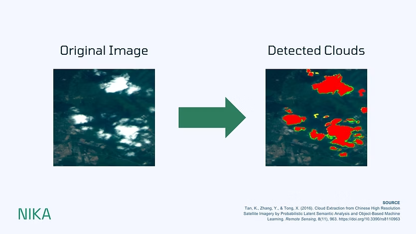
- Cloud Detection
- The process begins with identifying cloudy areas through brightness analysis. Clouds typically appear bright in visible wavelengths due to their high reflectivity. Using specialized algorithms, these areas are isolated and marked for removal.
- Data Reconstruction
- Once clouds are identified, a specialized algorithm runs and fills these removed areas using:
- Historical imagery from the same satellite
- Contemporary data from other satellites
- Advanced interpolation techniques
- Seamless Integration
- The final step involves blending the reconstructed areas with the original image, ensuring a natural transition between the replaced sections and the surrounding imagery.
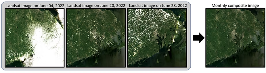
Figure illustrating monthly Landsat satellite image composite by the simple ratio algorithm proposed in the paper "Evaluation of Landsat image compositing algorithms."
The result is a clearer image with fewer or no clouds, which makes it easier to analyze what’s happening on the ground.
GenAI for Cloud Removal Processes
Cloud removal algorithms are also being radically transformed by AI. Instead of just swapping cloudy areas with older photos, AI can now predict what's actually under the clouds. This is achieved through deep learning models that have studied millions of landscape patterns, effectively learning to "see" through clouds.
Think of it as an intelligent artist who has studied countless landscapes – when they encounter a cloud-covered forest, they can reconstruct what's underneath based on learned patterns and context.
Nika is a team of passionate GIS engineers that makes solutions for real problems we encounter ourselves. Cloud removal is one out of many issues in GIS that we aim to solve with our tech. Our approach promises to push the boundaries of what's possible in satellite imagery analysis, making earth observation more reliable and accessible than ever.
Stay tuned for deeper insights into our innovative approach to cloud removal technology and more. We have some topic ideas that helps with processing your GIS data better, like:
- Handling snow cover vs. cloud cover
- Desert and water reflectance challenges
- Night-time imagery processing
We welcome your comments and feedback about this piece. Let us know which topics you'd like to covered next!
References:
- "Cloud Extraction from Chinese High Resolution Satellite Imagery by Probabilistic Latent Semantic Analysis and Object-Based Machine Learning" by Kai Tan, Yongjun Zhang and Xin Tong
- "Evaluation of Landsat image compositing algorithms" by Shi Qiu, Zhe Zhu, Pontus Olofsson, Curtis E. Woodcock, Suming Jin